Skip to product information
1 of 9

Atoms Marlyn VTOL Systems

Atmos Marlyn VTOL Drone

Atmos Marlyn VTOL Drone

Regular price $1.00 USD
Regular price Sale price $1.00 USD
Sale Sold out
Shipping calculated at checkout.

Atmos Marlyn VTOL Drone

DESCRIPTION

***Online pricing not available, Please request a quote:***

How To Get A Quote:

Option 1:
Contact Us to make sure you are getting the best unit possible. These machines are complex so let us help you get exactly what you need!

Option 2: (quickest response times)
Step 1. Add the item to your cart
Step 2. Checkout or Click on the Chat button box that is at the bottom right of your screen
Step 3. Please tell us any info you think we would need to know
Step 4. Relax, our team is processing your request and an expert will be in touch to get you exactly what you need!

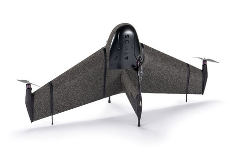
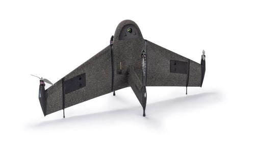
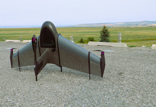
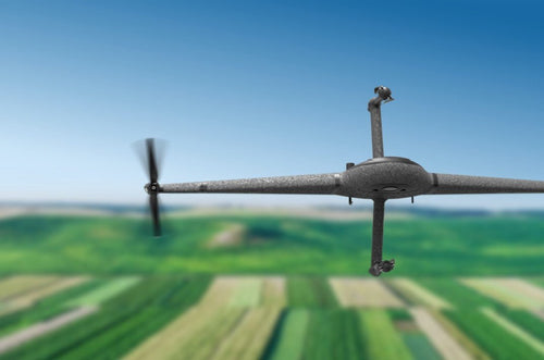
Atmos Marlyn - A mapping and surveying fixed wing VTOL drone that is redefining aerial surveying. The wingtip mounted propellers and large tailfin give Marlyn stability in survey/airplane mode, while constantly correcting attitude to get sharp aerial images in the toughest of winds. Marlyn is the UAV for those who need total control.

How is Marlyn Helping Surveyors?

Increased Efficiency

Take your data capture to the next level. Marlyn speeds up your data capture by surveying large areas up to 30x faster than traditional land surveying methods, and up to 10x faster than multicopter drones.

Survey Anywhere

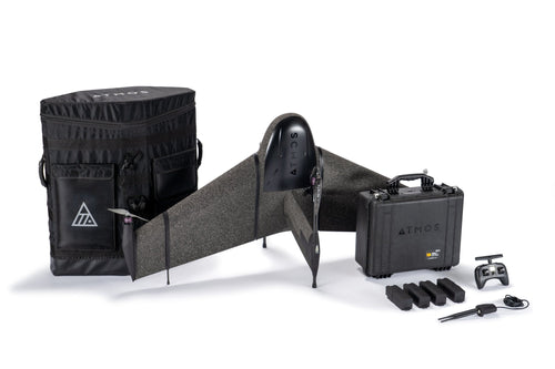
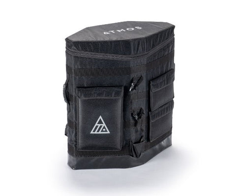
Marlyn only needs a 2x2m flat area to take off and land allowing you to be flexible in your operations. Easy backpack transport is also perfect for those heading off the beaten track.

Survey Anytime

With Marlyn 'no-go' days are turned into routine projects. You get the benefit of flying in wind conditions of up to 45km/h at ground level, and 55km/h at cruise altitude resulting in up to 30% more days per month.

Absolute Accuracy

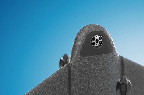
Accuracy is king in the surveying world. Attain accuracies as low as 1cm with Sony’s 42MP, full-frame RX1RII combined with Topcon's PPK module, an aerial surveying match made in heaven!

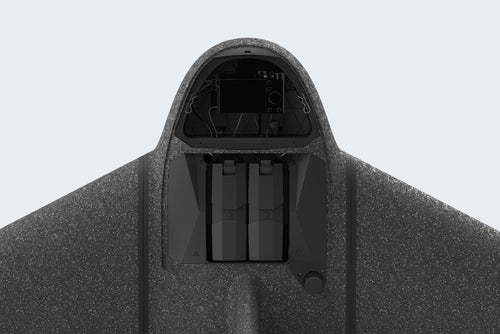
Dedicated Survey Cameras

Marlyn’s cameras are modular, meaning they're swappable in minutes. A variety of RGB and specialty cameras are available to suit your project requirements.

Fly More

Referencing localized weather data, Marlyn's Wind Benefit Calculator shows you how many more days in a year Marlyn can operate compared to competing products.

Get Results Easily with the Right Software

Developed with ease of use and data quality in mind, your in-field operation software Navigator and geo-referencing Geotagger will allow you to get survey-quality data without all the hassle and inaccuracies typically associated with some mapping drones.

The ATMOS Marlyn - Plan with Precision

FEATURES

  • Tailsitter Design:   Marlyn’s three part EPP foam body can be assembled by one person in a minute. It is rugged, flexible, and recyclable.
  • Atmos Autopilot:  No stress, with our integrated Auto Pilot your flight is automated from take off to landing.
  • Smart Battery System:  Marlyn's redundancy system gives you peace of mind; one battery functions as a fail-safe for the other and can bring Marlyn home if necessary. Handy indicator lights also provide a readout of the current state of charge.
  • Quick Swap Payloads:  In the field you can switch sensors in a minute. With Marlyn’s quick swap camera system you’re ready for any project.
  • Topcon PPK:  With an integrated high-end GNSS receiver, our Topcon PPK module gives Marlyn absolute X, Y, Z accuracy down to 1cm.
  • Operate from Any 2x2m Area:  Take off like a helicopter and fly like an airplane. With Marlyn you can operate from anywhere and cover up to 150Ha (370 Acres) per flight. No more finding large clear areas for belly landing.
  • Fly in the Toughest Winds:  With Marlyn you can take off, survey, and land comfortably in winds of up to 45km/h (28mph), more than any other survey drone. Surveyors deserve better than 30km/h wind limits!
  • Survey Anywhere:  with Marlyn’s dedicated backpack.

    APPLICATIONS

    Construction & Infrastructure:  Marlyn changes the game for land surveyors delivering operational efficiency, reduced downtime, and increased safety. With the PPK, accuracies down to 1cm [0.4in] are easily achieved with fewer to no ground control points.

    Surveying & GIS:  Compared to terrestrial survey methods, a drone survey yields a
    point cloud of millions of cm-accurate data points over a 150Ha area, giving you complete data coverage and a massive efficiency boost.

    Mining & Aggregates:  Marlyn eliminates the need for surveyors to move around the pit minimizing downtime and improving safety. Large, accurate data sets can be created efficiently, at reduced costs, with less man hours.

    Environmental Protection:  Marlyn is capable of seeing beyond the visual, providing new insights into plant health, animal behavior, and more, that was previously thought impossible. This allows you to glean a variety of data to both monitor and provide corrective actions to your study area.

    Precision Agriculture:  Marlyn’s multispectral cameras give you the ability to record crop health for larger terrains. Light reflectance in the visible and invisible spectra are used to determine plant stress on an individual level.

    SPECIFICATIONS

    OPERATION

    Take-off & landing area: 2 x 2 m [7 x 7 ft ] required
    Set-up time: 5 minutes
    Autonomous flight: Yes
    Take-off and landing: Automatic
    Emergency procedures: Automatic (configurable)
    Cruise speed: 65 km/h [40 mph]
    Wind resistance:
    • Take off: 45 km/h [28 mph] 
    • Cruise: 55 km/h [34 mph] 
    • Landing: 45 km/h [28 mph]
    Max flight time: 50 mins
    Pre-flight checklist: Integrated intelligent checklist in Atmos Navigator
    Temperature range: -10°C to +40°C [14°F to 104°F] (Above 35°C operating restrictions apply)
    GCPs: Not required with optional PPK module

    HARDWARE

    Drone Type: Hybrid (VTOL & fixed-wing)
    Weight without payload: 5.7kg (incl batteries)
    Max payload weight: Up to 1 kg
    Wingspan: 1.6 m (detachable wings)
    Built-in safety lights: 2 Navigation lights, 2 Anti-collision lights — 1km [0.6 miles] of visibility
    Motors: 4 electric motors
    Ingress protection: IP54 — It is not recommended to fly in fog, rain and snow
    Telemetry module range: Default 7km LOS
    Camera options: RGB (Sony RX1RII, A7C), Multispectral (Micasense RedEdge-MX, Altum)
    Included accessories: Backpack, 2x battery sets, charger, remote control, Navigator modem, maintenance kit
    Materials: Durable structural EPP with carbon fibre frame

    SOFTWARE
    Atmos Navigator: Marlyn's flight planning and telemetry software
    Atmos GeoTagger:  Marlyn's geo-referencing software
    Marlyn Update Center:  Marlyn's firmware upload software
    Operating system:  Windows
    Photogrammetry software:  Compatible with Pix4D, Metashape, SimActive, and more
    Input files: .KML, .KMZ, .GeoTIFF, .MBTiles, .WMTS
    Updates: Free

    IN THE BOX

    Aircraft

    Radio Connections:   Marlyn Radio Module & RC

    Battery Charger:   ISDT Double Charger (60min per pair)

    Batteries:   2 Sets — Each below 100Wh

    Portability:  Backpack & Accessories Case

    Software:  Navigator & GeoTagger (+ Updates)


          View full details